旅游~

背包旅行我的最爱~

美景~

眼睛看,镜头摄,心感受~

美食~

世上只有不合口味的美食~

摄影~

另一个角度看世界 值得收藏的回忆~

分享

我爱的地方,美景及美食~ 用照片与你分享^^

Monday, April 21, 2014

槟城美食-煎蕊 Penang Cendol


Source: Penang Tourism

槟城美食 - 炒粿条 Penang Char Kuey Teow


Source : Penang Tourism

槟城美食 - 叻沙 Penang Laksa


Source: Penang Tourism

Saturday, March 22, 2014

太鲁阁国家公园 Taroko National Park

太魯閣國家公園台灣第四座成立的國家公園,前身為日治時期成立之次高太魯閣國立公園(1937-1945)。戰後為省級風景區,1986年11月12日公告計畫,1986年11月28日成立管理處。位於台灣東部,地跨花蓮縣臺中市南投縣三個行政區。園內有台灣第一條東西橫貫公路通過,稱為中橫公路系統。
Taroko Gorge (太魯閣: Tàilǔgéis an impressive 19-km-long canyon, situated near Taiwan's east coast. The area of the gorge is also identified as Taroko Gorge National Park (太魯閣國家公園;Tàilǔgé gúojiā gōngyuán). The Taroko Gorge is composed mainly metomorphic rocks, such asmarble,gneiss, "schist",etc. The name, Taroko, means the "magnificent and splendid" in the language of Truku, the aboriginal tribe who resides in the area
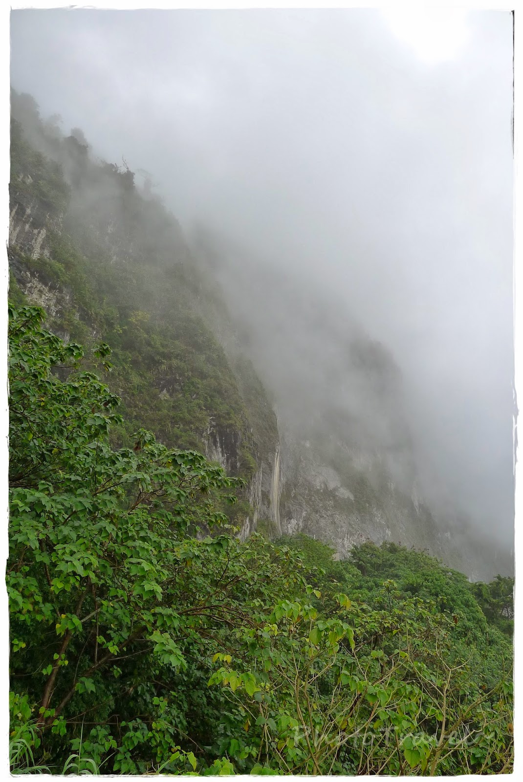
清水斷崖位於台灣花蓮縣秀林鄉的海岸斷崖,是蘇花公路和仁至崇德路段著名的旅遊景點。日治時期,台灣日日新報社讀者票選為臺灣十二勝之一,當時之斷崖道路的稱呼是從姑姑子斷崖開始,今日仍能隱約在舊和平隧道看到往昔的題字。
Qingshui Cliff (Chinese: 清水斷崖; Hanyu Pinyin: Qīngshuǐ Duànyá; Tongyong Pinyin: Cingshuěi Duànyá; Wade–Giles: Ch'ing1-shui3 Tuan4ya2) is a 21 kilometer length of coastal cliffs averaging 800 meters above sea level in Hualien County, Taiwan.[1] The tallest peak, Qingshui Mountain, rises 2408 meters directly from the Pacific Ocean. The cliff is located at the southern part of the Suhua Highway that connects the counties of Yilan and Hualien in eastern Taiwan. It is considered to be a very scenic area[2] and is the highest coastal cliff in Taiwan.


砂卡礑步道從入口處到三間屋全長約4.5公里,倚傍著砂卡礑溪而行。砂卡礑溪十六公里的流路中,形成峻秀的峽谷,清澈的溪水、美麗的岩石褶皺及蓊鬱的森林;步道沿途過去曾有多個原住民聚落,讓砂卡礑步道兼具景觀生態與人文之美。砂卡礑溪溪床上鋪滿大大小小的壘石,以大理石與片麻岩最多,湛藍湍急的溪水滑過溪床,與溪石合奏出清亮的自然樂音,而溪水也將岩石琢磨得圓滑柔美。褶皺在兩岸山壁和溪中岩石上形成一幅幅抽象壁畫,任人欣賞想像。
砂卡礑步道海拔約六十公尺,屬於陰濕的河谷地形,但植物生態卻呈現出乾濕兩型的特色。坡度較緩的地方,生長高大且層次豐富的林木;坡度較陡的地方,只見低矮的岩生植物,以台灣蘆竹和沿階草居多。茂密的森林,清澈的溪水,提供動物良好的棲息環境,動植物生態豐富,使砂卡礑步道處處展現生機。
砂卡礑步道平緩易行,除了可沿途作自然觀察之外,步道全線亦設置十餘座大小觀景平台,供小憩賞景,還有幾處親水小徑可以直下溪谷,觀察溪流生態及岩石的紋理,聆聽自然美妙的樂音。

The Shakadang Trail, as of October 2013, was only open to the 5D Cabin, and takes about 45 minutes going one way at a moderate pace. It follows the path of the Shakadang River below, which is extraordinarily pristine and wonderful to behold. This path is well worth your time. Note: If you decide to take the Taroko Shuttle Bus, the Shakadang Trail is only accessible when you are on a bus that is entering the park (from Hualien Train Station going to Tianshiang); the bus going back does not make a stop here. If you get off at the Park HQ to get some maps, you can also walk about 0.6 km through the tunnel on a pedestrian walkway to the Shakadang Trail in about 10-15 minutes.


Source : Wiki/维基,taroko.gov.tw

Monday, July 22, 2013

Seoraksan 雪嶽山


Seoraksan National Park Entrance
 
Seoraksan is the highest mountain in the Taebaek mountain range (태백산맥) in the Gangwon Province in eastern South Korea. It is located in a national park near the city of Sokcho. After the Hallasan volcano on Jeju Island and Jirisan in the south, Seoraksan is the third highest mountain in South Korea. The Daechongbong Peak (대청봉) of Seoraksan reaches 1,708 metres (5,603 feet). The Taebaek mountain chain is often considered the backbone of the Korean peninsula ~ Wikipedia~
 
国雪岳山(又名雪狱山)韩译:설악산。朝鲜半岛东部太白山脉最高峰。在韩国境内。海拔1708米。主峰白青峰。一年有5-6个月积雪。森林、高山植物的集中地,登山者多。是金刚山的延续,有“南金刚”之称。雪岳山位于东海岸的北端江原道,海拔1708公尺高。以前雪岳山也称为雪山或雪峰山.此名称指的是世界上最高峰的意思。雪岳是翻译为汉字的名称。于1970年被韩国政府指定为国家公园,它占地大约373平方公里,是第二大国家公园。而且,因为雪岳山保有500多种野生动物及1000多种稀有动物,被UNESCO指定为“韩国唯一的植物保存地区”其中以枫叶最为著名。雪岳山景点有:阿尔卑斯滑雪场、神兴寺、五色药水、马登岭、大声瀑布、卧臣台、飞仙龟、权金城等。~Baidu~
 
Directions
From Sokcho Intercity / Express Bus Terminal, take Bus 7 or 7-1.
Get off at Seorak-dong (설악동, the last stop).
1. 於束草市內乘7,7-1號公車,於雪嶽山入口下車,約需30分左右。
2. 束草客運巴士站乘計程車至雪嶽山入口約15~20分左右。
 
Bronze Buddha of Sinheungsa


View Larger Map

Friday, July 19, 2013

Haedong Yonggungsa Temple 海東龍宮寺 @ Busan 釜山


Haedong Yonggungsa Temple is situated on the coast of the north-eastern portion of Busan. This superb find of a tourist spot and temple offers visitors the rare find of a temple along the shore line. Most temples in Korea are located in the mountains. Haedong Yonggungsa Temple was first built in 1376 by the great Buddhist teacher known as Naong during the Goryeo Dynasty. Haesu Gwaneum Daebul (Seawater Great Goddess Buddha), Daeungjeon Main Sanctuary, Yongwangdang Shrine, Gulbeop Buddhist Sanctum (enclosed in a cave), and a three-story pagoda with four lions can all be seen looking out over the ocean. 

The main sanctuary of the temple was reconstructed in 1970 with careful attention paid to the colors that were traditionally used in such structures. On the right-hand side, inside the a cave, is a uniquely designed Buddhist sanctum, while situated just in front of the main sanctuary is a three-story pagoda with four lions. The four lions are symbolizing joy, anger, sadness, and happiness. Other special sites at the temple are the 108 stairs and stone lanterns lining the rocky landscape. After going down the 108 steps, one will be delighted with the beauty of the temple. Midway down the 108 steps one can stop and enjoy the calming sounds of the waves, and view the majestic sunrise. ~Visit Korea~


靈驗的許願地-海東龍宮寺(釜山)
海東龍宮寺由高麗恭民王的王師懶翁和尚建於1376年,是韓國三大觀音聖地之一。結合海、龍與觀音大佛,讓此處比其他地方有更深層的信仰意義。傳說只要在此處真心誠意的祈禱,就能獲得托夢並實現一個願望。

曾因壬辰倭亂被燒毀,1930年代初期由通度寺的雲崗重建。1974年晸菴上任時發願要復原觀音道場,祈禱了百日之後,他夢裡出現了乘著龍、身穿白衣的觀世音菩薩,所以將寺廟改名為海東龍宮寺。

現存的建築物以大雄殿為主,另外還有窟法堂、龍王堂(龍宮堂)、梵鐘閣、寮舍齋等,大雄殿為住持晸菴於1970年代重建。大雄殿前的窟法堂被稱為彌樂殿,供奉著從寺廟創建起就存在的彌樂坐像石佛,有許多沒有子嗣的信徒們前來求子,因此又被稱為得男佛。

大雄殿前有四獅子3層石塔,原來這個位置有高3m的石頭(彌樂石),壬辰倭亂時寺廟成了廢墟,6.25戰爭時為了建造海岸警備網而將其破壞。1990年,住持晸菴收集了被破壞的石頭,用來補強損傷的庵壁,並建築了這座石塔,供奉著從斯里蘭卡帶回來的7塊佛舍利。

除此之外,寺廟還有韓國最大的單一素材約10m高的石像海水觀音大佛,又被稱為東海笠岩佛祖的藥師如來佛。寺廟入口有交通安全祈願塔與108階,階梯入口有達摩像,據說摸了他的鼻或肚子就能得到男嬰。~Visit Korea~

108階梯
108 steps


                                                                                             View Larger Map

Wednesday, June 19, 2013

Gwanghwamun Square 光化門廣場 @ Seoul 首尔

Gwanghwamun Square (Hangul광화문광장Hanja光化門廣場, also known as Gwanghwamun Plaza) is a public open space on SejongnoJongno-gu in SeoulSouth Korea.The plaza was opened on 1 August 2009 by the Seoul Metropolitan Government and is part of the City's plans for environmentally friendly renovation projects such as the Cheonggye Stream and Seoul Plaza. It is also of historical significant as the location of royal administrative buildings, known as Yukjo-geori or Street of Six Ministries; and features statues of Admiral Yi Sun-sin of Joseon Dynasty and King Sejong the Great of Joseon.~ Wikipedia~

Statue of King Sejong the Great of Joseon


光化门广场是拥有600年历史的首尔中心街区, 背靠美丽雄伟的北汉山和古建筑群景福宫,复原世宗路古貌——六曹街建成的历史文化体验中心。
位于首尔市钟路区光化门的光化门广场连接了钟路十字路口和清溪广场,中心广场长550米,宽34米。被赞为“光化门史复原广场”、“六曹街风景再现广场”、“韩国代表广场”、“市民城市文化广场”、“城市里面的广场”等。
六曹街是朝鲜太祖时代(1392~1398)建设汉阳都城时开创的街道,是了解朝鲜时代道路施工方法的重要遗迹。
首先可看到李舜臣将军的铜像(1545~1598),其周边是一些地面喷泉和镜子喷泉等各式各样的喷泉。一到晚上在灯光的照耀下绚丽多彩,还会定期上演精彩的喷泉秀。在铜像处观望广场左右,两旁是沿着朝鲜时代六曹街流淌的水路。水路中刻有自朝鲜建国1392年起至2008 年的韩国历史主要内容,水流与喷泉交汇后流向清溪川
后面是创造韩文的世宗大王(1397~1450)的铜像。世宗大王铜像就在李舜臣将军铜像后方250m处。
~转载自游多多旅行网~


The statue of the Admiral Yi Sun-sin